Planning Application
A planning application for the Mullaghclogher Wind Farm, located approximately 4km north east of Plumbridge and 11.5km south west of Claudy, in the townlands of Stroanbrack, Doorat and Glengarrow, within the Derry City and Strabane District Council area, located within County Tyrone, Northern Ireland, was validated in May 2025.
Electronic copies of the planning application and accompanying documents can be viewed or downloaded by clicking on the links below.
The planning application may also be viewed on the Northern Ireland Direct planning portal at https://planningregister.planningsystemni.gov.uk/simple-search. The planning reference number is SPD/2025/0011/F.
The full Environmental Statement, together with supporting documents submitted as part of the planning application, is also available for viewing1 during normal opening hours at:
Learmount Resource Centre
Old School Lane
192 Learmount Road
Park Village
Derry
BT47 4BA
Pre-Application Community Consultation (PACC) Report
Volume 1 - Non-Technical Summary
- Non-Technical Summary (updated Aug 25)
Volume 2 - Environmental Statement Main Report
Volume 3 - Figures
- Figure 1.1 Site Location
- Figure 1.2 Planning Application Boundary
- Figure 1.3 Infrastructure Layout
- Figure 1.4 Typical Wind Turbine Elevation
- Figure 1.5 Control Building and Substation Compound Layout
- Figure 1.6 Control Building Elevations
- Figure 1.7 Control Building and Substation Elevations
- Figure 1.8a indicative Battery Energy Storage System (BESS) Compound
- Figure 1.8b indicative BESS Compound
- Figure 1.8c Indicative BESS Compound
- Figure 1.9 Typical BESS Container Elevation
- Figure 1.10 Site Entrance Layout
- Figure 1.11 Typical Access Track
- Figure 1.12 Temporary Construction Compound Layout
- Figure 1.13 Temporary Construction Compound Elevation
- Figure 1.14 Temporary Enabling Works Compound
- Figure 1.15 Wind Turbine Foundation
- Figure 1.16 Crane Hardstanding General Arrangement
- Figure 1.17 Typical Cable Trench
- Figure 1.18 Typical Drainage Details
- Figure 1.19 Typical Water Crossing Design
- Figure 1.20 Typical Bottomless Culvert
- Figure 3.1 Turbine Layout Evolution
- Figure 3.2 Combined Constraints and Infrastructure Layout
- Figure 3.3 Infrastructure Design Evolution
- Figure 4.1 Landscape Designations and Classifications
- Figure 4.2 Landscape Character Areas
- Figure 4.3 Viewpoint Selection
- Figure 4.4 Cumulative Baseline
- Figure 4.5 ZTV 15km radius hub height
- Figure 4.6 ZTV 30km radius hub height
- Figure 4.7 Reverse ZTV 15km radius blade tip height
- Figure 4.8 Cumulative ZTV 30km radius blade tip height
- Figure 4.9 NOT USED
- Figure 4.10 VP1 Balix Upper to west of site
- Figure 4.11 VP2 Glenmornan Road, Owenreagh
- Figure 4.12 VP3 Stroanbrack Road near B48 and Aghanbrack GAA
- Figure 4.13 VP4 Craig to north of site
- Figure 4.14 VP5 Lough Ash
- Figure 4.15 VP6 Bradkeel Road upper to south of site
- Figure 4.16 VP7 Fairview Road, Plumbridge
- Figure 4.17 VP8 Slievebeg Road near B48 to south of Plumbridge
- Figure 4.18 VP9 B48 between Plumbridge and Gortin
- Figure 4.19 VP10 Plumbridge at river in village centre
- Figure 4.20 VP11 Barnes Gap
- Figure 4.21 VP12 Robber’s Table footpath to south west
- Figure 4.22 VP13 Viewing Area on Lenamore Road, Gortin
- Figure 4.23 VP14 Fingrean Road near A505
- Figure 4.24 VP15 Gortnagranagh Road, Bessy Bell
- Figure 4.25 VP16 South-facing side of Eglish Hill
- Figure 4.26 VP17 Near Carrickatane
- Figure 4.27 VP18 Crockandun Viewing Area, Slieve Gallion (top) and VP19 Benbradagh (bottom)
- Figure 5.1 Heritage Assets
- Figure 6.1 Designated sites within 15km
- Figure 6.2 JNCC Phase 1 Habitat Map
- Figure 6.3 NVC Phase 2 Habitat Map
- Figure 6.4 NVC Quadrant Locations
- Figure 6.5 Habitat Management Areas
- Figure 7.1 Automated Static Bat Detector Locations
- Figure 7.2 Badger and Otter Survey Results CONFIDENTIAL
- Figure 7.3 Common Lizard Survey Results
- Figure 8.1 Ornithology Viewpoint Coverage
- Figure 8.2 Locations of Red Grouse
- Figure 8.3 Locations of Snipe Territories
- Figure 8.4 Locations of Breeding Moorland Passerines 1
- Figure 8.5 Locations of Breeding Moorland Passerines 2
- Figure 8.6 Flightlines for Annex-1 Species
- Figure 8.7 Peregrine Flightlines
- Figure 8.8 Buzzard Flightlines
- Figure 8.9 Kestrel Flightlines
- Figure 8.10 Wider Area Raptor Map
- Figure 9.1 Overview of Site Location in Relation to Key River Catchments
- Figure 9.2 Local Streams in Relation to Proposed Development
- Figure 9.3 Salmonid Habitat Eden River
- Figure 9.4 Salmonid Habitat Stroanbrack
- Figure 9.5 Salmonid Habitat Glengarrow and Main Burndenet
- Figure 9.6 Sampling Locations
- Figure 9.7 Salmon and Trout Fry Abundance
- Figure 10.1 Site Hydrology
- Figure 10.2 Site Water Quality Assessment
- Figure 10.3 Designated Sites
- Figure 11.1 Predicted Noise Footprint
- Figure 11.2 Predicted BESS Footprint
- Figure 12.1 Turbine Delivery Route
- Figure 12.2 HGV Delivery Route
- Figure 13.1 Shadow Flicker Assessment
Volume 4 - Technical Appendices
- TA1.1 RES Letter of Intent to Submit Environmental Statement
- TA1.2 DFI response
- TA1.3 Proposed Battery Energy Storage System
- TA1.4 Potential Grid Connection Route
- TA1.5 Outline Construction Environmental Management Plan
- TA1.6 Proposed Turbine Lighting Scheme
- TA4.1 LVIA Plates, Table and Figures, Glossary and References
- TA4.2 LVIA Methodology
- TA4.3 Landscape Character Areas
- TA4.4 Viewpoint Selection
- TA4.5 Cumulative Baseline
- TA5.1 Cultural Heritage Baseline Assessment
- TA5.2 Heritage Viewpoints
- TA6.1 Ecology Annexes
- TA6.2 Outline Habitat Management Plan
- TA7.1 Bat Survey Report
- TA7.2 Badger and Otter Report CONFIDENTIAL
- TA8.1 - 8.17 Ornithology
- TA10.1 Surface Water Management Plan
- TA10.2 Flood Risk and Drainage Assessment
- TA10.3 Peat Landslide Hazard and Risk Assessment
- TA10.4 Peat Management Plan
- TA10.5 Consultations
- TA11.1 Assessment of Battery Energy Storage Facility
- TA11.2 Scope of Assessment
- TA11.3 Calculating Standardised Wind Speed
- TA11.4 Background Noise Survey Photos
- TA11.5 Instrumentation Records
- TA11.6 Charts
- TA11.7 Suggested Planning Conditions - Noise
- TA12.1 Delivery Analysis
- TA12.2 Passing Bay Locations
.
Site Location Plan

Click on image to enlarge
infrastructure Layout
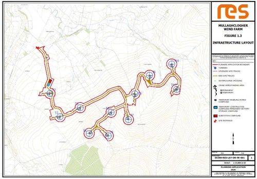
Click on image to enlarge
Zone of Theoretical Visibility (30 km radius, hub height)
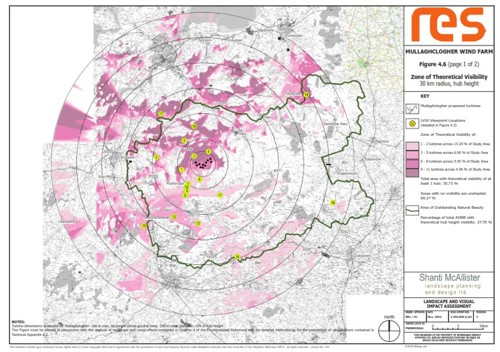
Click on image to enlarge
Habitat Management Areas
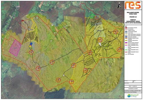
Click on image to enlarge
Reasons to Support the Mullaghclogher Wind Farm Proposal
Delivering local jobs and investment
The renewables industry continued to deliver investment and jobs during the previous downturn and during the current cost of living crisis, with the ever-growing threat of climate change, it is more important than ever that we invest in a green economy. Mullaghclogher Wind Farm is predicted to deliver approximately £35 million into Northern Ireland’s economy, if consented.Cheapest form of renewable energy
Onshore wind, alongside other renewable technologies, are the cheapest form of electricity generation. It can be deployed quickly and delivered at lower costs than hydro, marine technologies, and nuclear.
Between 2020 and 2023, renewable electricity, of which around 80% was from onshore wind, saved each NI consumer £160 off their bills2.
Helping to tackle climate change
Northern Ireland’s Climate Bill sets a target of 80% of electricity consumption from renewable sources by 2030, and it is expected that 65% of this will need to come from onshore wind. If consented, Mullaghclogher Wind Farm would be capable of generating 66MW of clean, low cost electricity, equivalent to the electricity usage of around 80,000 homes each year3.
Energy Security
A key policy driver for the development of renewable energy in Northern Ireland is the need to increase energy security. There are potential adverse impacts on local populations and the economy through highly volatile fuel costs, contributing to fuel poverty and high energy costs for businesses and industry.
In addition, increasing focus on home-grown renewable energy can deliver environmental and climate change gains, reductions in carbon emissions, as well as investment and employment opportunities.
With a lack of indigenous fossil fuels and no nuclear power stations, Northern Ireland is keen to develop the full range of its available renewable energy resources to optimise the contribution that renewables make to the overall energy mix.
Developed by a known and reputable developer
RES has been building wind farms in Ireland since the early 1990s with an office in Larne, employing many local people across a range of disciplines. RES has developed and or constructed 29 onshore wind farms in Northern Ireland totalling in excess of 500MW and operates over 134MW of wind capacity across Northern Ireland.
RES also have a strong track record within Northern Ireland of consulting and working closely with the local community, key stakeholders, and the local supply chain to deliver projects which maximise much-needed inward investment. At sites constructed near Limavady in 2022, some 16 NI based contractors and suppliers were used during the construction phase.
If, having read the above, you would like to support the Mullaghclogher Wind Farm proposal, you can do so by submitting a comment on the Planning Portal. The planning reference is SPD/2025/0011/F.
1 The planning documentation is no longer available for viewing at Aughabrack & District Community Association, 253 Lisnaragh Road, Dunamanagh, Strabane, BT82 0SD.
2 https://renewableni.com/wp-content/uploads/2024/09/Renewable-Rewards-Baringa-Report-online.pdf
3 The homes figure has been calculated by taking the predicted annual electricity generation of the site (based on RES assessments Mullaghclogher has a predicted capacity factor of 48.2%) and dividing this by the annual average electricity figures from the Department of Business, Energy and Industrial Strategy (BEIS) showing that the annual UK average domestic household consumption is 3,509 kWh (Dec 2022).